In light of our recent popular blog post about the regions of Colorado, let’s now share fascinating and entertaining insight into our geography and geology. Note: This is not like your high school history class!
Located 740 miles from the Pacific Ocean and twice that far from the Atlantic Ocean, Colorado comes up from the High Plains starting at 3,315 feet above sea level, and it climbs to 14,400 feet above, which is at the peak of Mt Evans.
Cripple Creek KOA is the highest elevation campground not just in Colorado but in the world! It’s at 10,000′ above sea level.
Leadville is the highest elevation incorporated city in the country, setting at 10,430 feet elevation.
Twin Lakes, near Buena Vista and Leadville, lays adjacent to the two natural lakes at the foot of Colorado’s highest Fourteener, Mt. Elbert. The peak 14,439′ and was first ascended in 1874.
An amazing 75% of all U.S. land over 10,000 feet is right here in Colorado.
Colorado’s Grand Mesa is the world’s largest flat-top mountain. Wiki says, “It has an area of about 500 square miles and stretches for about 40 miles east of Grand Junction between the Colorado River and the Gunnison River.”
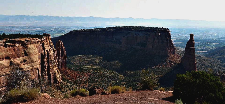
Colorado National Monument is nicely summed up in their website: “Towering monoliths exist within a vast plateau and canyon panorama. You can experience sheer-walled, red rock canyons along the twists and turns of Rim Rock Drive, where you may spy bighorn sheep and soaring eagles.”
Colorado is home to the highest paved road on our continent. It’s the road to Mt. Evans off of I-70 from Idaho Springs. On that road you’ll climb to 14,258′ above sea level.
The Durango & Silverton Narrow Gauge Railroad climbs from Durango’s 6,512 feet above sea level to Silverton’s 9,305′. It operates all year and has been in continuous operation since 1881. It was originally constructed to haul gold and silver from the San Juan Mountains. “Did you also know that it runs right through United Campground of Durango?
Of our 104,185 square miles of land, the federal government owns more than 1/3 of it! Most of it is undeveloped. No wonder our land is sought out by outdoors enthusiasts from around the world!
Even in our metro areas, Coloradans love the outdoors! Denver has 205 parks within its city limits, making it the largest city park system in the nation.
Denver sets at one mile above sea level; thus its nickname Mile High City. Actually, the 13th step of the state capital building in Denver is exactly a mile above sea level.
When you travel I-70 west of Denver, you’ll drive through the Dwight Eisenhower Memorial Tunnel. It’s the highest auto tunnel in the world. It was bored at an 11,000 feet under the Continental Divide. The tunnel is 8,960 feet long, and you’ll likely be one of over 26,000 vehicles to travel that tunnel on that day.
Pikes Peak is a dozen miles west of Colorado Springs and it rises to 14,115 feet above sea level. It offers stellar views! It’s been said that after having seen those views, Katherine Lee Bates wrote “America the Beautiful.”
The Pikes Peak Cog Railway is the highest railway train in the world and it runs on a special track.
Colorado’s earliest popular nationwide slogan “Pikes Peak or Bust,” which launched the Colorado Gold Rush, began in July 1858. Thousands of fortune hunters began flocking in. Central City’s rush began in 1859 with the Gregory Lode. While there was plenty of gold and silver, most we trekked failed to find it.
Alamosa is home to the tallest sand dune in America: Great Sand Dunes National Monument. This was formed by ocean waters and wind more than one million years ago.
The Rocky Mountains run right through Colorado on their 3,000-mile stretch from Canada to New Mexico. The rise to over 14,000’ in elevation (often referred to as Fourteeners), and Colorado is home to 52 Fourteeners.
When Colorado residents of around 600 AD made us their home, they built an elaborate four-story city carved in the cliffs that are in Mesa Verde National Park. Much remains a mystery, but they left us with over 4,000 identified structures.
Speaking of southwest Colorado, the corner of our state is the only point where the corners of four states meet: Colorado, Arizona, New Mexico and Utah. This area is aptly named Four Corners.
Colorado boasts of many hot springs but Glenwood Springs is home to the world’s largest natural hot springs pool. It’s a two-block long pool!
Florissant Fossil Beds National Monument, near Woodland Park and Cripple Creek, shows us what happened when the Guffey Volcano erupted millions of years ago. You can still see the fossils and petrified trees!
To close this up, let’s also brag about our sunny days! This post tells us what we Coloradans already know: we have over 300 sunny days a year!
As you study the listings on CampColorado.com, you’ll find the elevation showing for many campgrounds. Elevation is also talked about in these other blog posts:
Our Find a Campground page makes it easier to narrow the list of campground to those which best suit your preferences.
This publication is supported by funding from the Colorado Tourism Office, a state agency. Turn to Colorado.com for a comprehensive list of festivals, events, historic areas, itineraries, and community insight.

